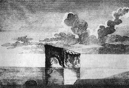
Varashev's Stone
|
|
The natural border between rocks and skerries of the Northern Ladoga Coast and open places of Olonets planes coincided in the ancient times with the bother between Korela and Ves tribes and in 1617-1721 and 1811-1940 was official state border. Since 1618 this border is marked by two ancient border marks – Varashev's Stone (Variskivi), laying in the waters of Ladoga Lake near Manssila village and Virtelä village border mark, seriously damaged by now, standing on the old trade route, going along the beach of Ladoga Lake. According to Stolbov 1617 Peace Treaty Swedish and Russian border setting ambassadors met in 25th of October on the shore of Ladoga Lake to proceed border marking between Solomenny pogost (circuit) of Korela uezd (district) and Olonets pogost of Novgorod uezd. The "The First Full Assembly of the Laws of the Russian Empire" says about it: And the first there been the border of Olonets pogost of Novgorod uezd and Solomenny pogost of Korela uezd starting from Ladoga Lake from Varatchin's Stone that sits in the water afar from the cape and on it there are marks – a Cross in the circle and the Crowns and the Year." The Russian-Swedish border, set by Stolbov Peace Treaty, was not a peasful one for a long. Already in 1654 Russian occupied the center of the border circuit Salmi village. Next year Sweds attack Olonets. After the Northern War the Northern Ladoga shore became Russian in accord with Uusikaupunki Peace treaty. A hundred years border line seized to be effective. |
 1785. Varashev's Stone. The drawing from the book by academician N.Ozeretskovsky "Travelling by Ladoga and Onego lakes" |
|
Academician N. Ozeretskovsky in his book "Travelling by Ladoga and Onego lakes", published in 1788 writes about Varashev's Stone: |
 1785. Marks on Varashev's Stone. The drawing from the book by academician N. Ozeretskovsky "Travelling by Ladoga and Onego lakes" |
|
They say that this stone was a long time ago a border stone between Sweden and Russia, but why it is called Varashev Stone nobody could tell. Now it serveth as a border stone between Serdobol and Olonets districts." In 1811 the Northern Ladoga shore was reunited to the rest of Finland, that became the Autonomous Grand Duchy inside Russian Empire. The old border again became administrative and custom border between The Autonomous Grand Duchy of Finland and the rest of Russia. Olonets student of local lore Ivan Kondratyev mentioned Varashev's Stone in his "The notes on foundation of Olonets", written in 1836 (published in "Olonets Collection" only in 1804). In the second part of XIX century a hydrographer A.Andreev writes about Varashev's Stone in his book "The Ladoga Lake": In 1886 in the "Olonets Collection" magazine there was publishes a report of an acting secretary of Olonets region statistical committee A.Ivanov about special research expedition "Varashev's Stone and the stone on the Serdobol highway". The old border became The State Border again after proclaiming the independence by Finland. It was confirmed by both sides by Tartu Peace Treaty in 1920. At night of November 30th 1939 Soviet troops crossed the border. The bloody Winter war, that moved the border far to the west, has started. |
|
Another, much less known border mark is situated in Virtelä on the ancient road going along Ladoga shore. Initially it has inscription in Latin: "Huc Regni posuit fines Gustavus Adolphus, Rex Svecorum; fausto numine duret opus. (Up to this place goes the State Border of Gustav Adolf. The Gods helping hand – this work is solid.) 1617.", that was practically destroyed by now. The stone itsels was laid down, broken to peaces and used as a basement for fires.
Special Thanks to I.Chernyakova for the help in gathering materials for this page.
|